Cairnpapple by Jackie Queally
The Bathgate Hills are not one of Scotland's famous beauty spots, not because they are undeserving but more than likely because their position within a network of main transport routes between Edinburgh, Glasgow and Stirling makes is an unlikely spot to imagine a serene scene of rolling hills, where if you climb above the old mining town of Bathgate you rise into another world that the rushing world in the main has passed by. A haven for ponies and cyclists, it is often so still when I visit it I can hear for miles.
The Romans when they came by on a reconnaissance trip in the early Christian era recorded the ancient cairn of Cairnpapple as "media nemeton", meaning "central sanctuary" of the highest order of Druids. Set upon the one thousand feet summit of the Bathgate Hills, the view on a clear day extends to Goat Fell on the isle of Arran in the west and Bass Rock in the Firth of Forth in the east. The central belt of Scotland is a narrow isthmus of land bound by the Firths of Clyde and Forth and Cairnpapple affords the best view of it all. Renowned as a wisdom school, Cairnpapple was one of Scotland's foremost centres for learning.
Cairnpapple
The oldest monument extant in the Bathgate Hills is without doubt Cairnpapple. Cairnpapple was discovered immediately after the Second World War - all that was discernable at the time was a rough circular embankment known as a henge monument - and a central cairn set in a rather random-looking position within the circle. All was overgrown with long grass with a strange octagonal turf wall surrounding it - there used to be a plantation of trees within this but only a few remained. Professor Stuart Piggott excavated this late Neolithic site in 1947 and 1948. He discovered a complex site - the site is like a jigsaw puzzle with an overlaying sense of presence that lends that crucial element to any sacred site. A multi-coloured plasticene model of the site at various stages through history is on display in the Nissan hut managed by Historic Scotland on site - this is the best visual representation of its multi-layered use.The earliest evidence of human usage of site was 3500 BC when (ceremonial?) fires were lit by the Neolithic farmers who would have lived in the plains below. Axe heads from Cumbria and Wales were found in the hearths, proving that movement between these areas dates back much further than Celtic times. (In the sixth century AD these old Celtic kingdoms welcomed the migrating Celtic tribes from mid-Scotland who were ousted by the Saxons).
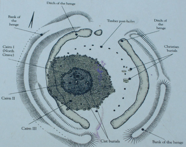
The second phase of use of site is marked by a Class 2 henge (henge with double opening) which dates from around 3000 BC. The henge surrounded twenty four upright posts, which Piggot believed were stone. Later theories supported wooden posts, but there has been some recent reversion to support the idea of it being a stone circle. The circle can be more accurately described as an oval, and there are two inliers that align with their respective partner stones identified in the oval: one of these sets is to one side of the north entrance and another set in the vicinity of the south entrance.
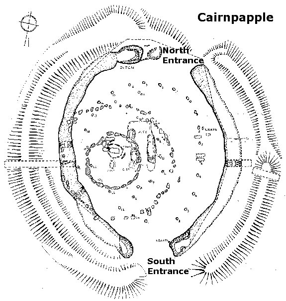
When standing in the north entrance and facing southwards the southernmost uprising of the moon would be seen in midsummer.
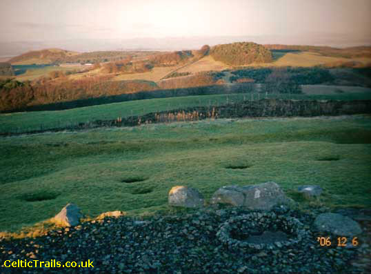
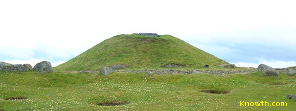
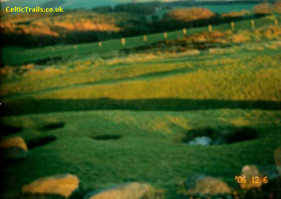
View from top showing Inlier at North End of Cairnpapple
Three central cairns were added when the circle as a ceremonial site became obsolete; a series of three successive burials were placed with ceremonial Beaker pots. The first and largest grave is known as the North grave and is over the site where the early fires were lit. If you extend the line connecting a stone in the circle with its counterpart inlier stone at the north entrance it reaches the tip of the North grave where the largest stone stands 2.4 meters high, although before the site was excavated very little of if showed above the surface! Nowadays the central burial cairns inside the circle are protected with a concrete dome that has then been grassed over, so it is not possible to see straight across the circle as it was in ancient days.
 The
North grave is unparalleled in Scotland - whoever was buried here was wrapped in some form of organic material
and her grave strewn with flowers. Her face was covered with a burnt wooden mask and a burnt club or mace
placed alongside her. The find evokes strong emotions among many of the local people, who believe the person
buried was female and connected to fertility.
The
North grave is unparalleled in Scotland - whoever was buried here was wrapped in some form of organic material
and her grave strewn with flowers. Her face was covered with a burnt wooden mask and a burnt club or mace
placed alongside her. The find evokes strong emotions among many of the local people, who believe the person
buried was female and connected to fertility.
The stone oval and ovoid henge is reminiscent of the female ovulation circle dictated by the Moon, and there is an alignment with the moon in the laying of this grave. The head of the grave is on its alignment. Interestingly the Bathgate Hills are often perceived as being "feminine" in character. Perhaps the site was dedicated to the moon as it lay in close proximity to a precious mineral that held associations with that planet: silver.
Immediately beside the cairn, within a stone's throw of the summit lie the ancient Hilderstane Silver Mines that were used until the seventeenth century. The Crown Jewels on display in Edinburgh Castle were made from the silver in these mines as it yielded the best quality silver to be found in Scotland.

Silvermines by Cairnpapple
Silver as a crystal is closely aligned with the energies of the Moon, and in the medieval times it would have been a commonplace belief that the crystal and its loci were associated with the moon. The twenty four stones set within an oval suggest a Sun - Moon calendar was observed in this early astronomical observatory on top of a holy hill site. The people in the Bathgate Hills were farmers and the agricultural year depended on a close understanding of the inter-relationship of Sun and Moon. An old standing stone known as the Clinking Stane still stands above the town of Bathgate on the approach road to the cairn - this was the stone at which lovers would meet to betroth themselves to one another - when I asked a local archaeologist if he knew what "Clinking" meant, despite being very local his knowledge did not extend to local dialect - my explanation that it meant "kissing" caused an intense blushing not intended! Again, the notion of fertility is approached with the aspect of betrothal and love.
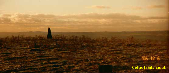
Clinking Stone above Bathgate
Other stewards have been more convinced from the start that there was a lot of energy at the site and have contributed to more understanding of the site. The twenty four stones that stood inside the henge were dismantled at some point after it ceased to be a place of ceremony, and perhaps were re-used to house a large cairn that surrounded all three aforementioned graves, and yet only twenty one kerb stones can be counted. Professor Piggot of the first dig thought one of the stones was taken down to the preceptory of the Knights of St John in the village below.
The third grave inside the cairn had disappeared during excavation and one steward on site discovered by close study of photography that its capstone had been moved to around the outer edge of the circle, where many stones still lie. Nearby he also discovered that one of these outer circle recumbent stones altered its magnetic field so that wherever the compass was laid the needle pointed to its centre- some believe this indicates an energy vortex while others put it down to the possibility that the loadstone (iron) content in the stone was re-aligned after volcanic activity. Even others point to the local transmitter and blame it for the weird magnetic behaviour, although that would not explain why other stones close by have not reacted in this fashion.
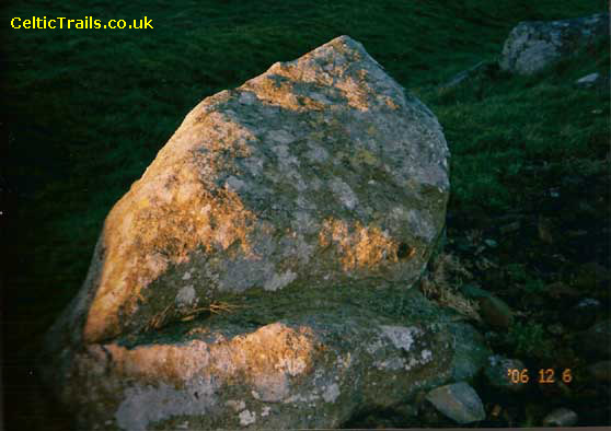
Magnetic Stone
When I bring visitors to the circle I encourage them to dowse with rods and pendulums and test the magnetic bearings - one young artist when dowsing for the first time in his life received a temporary strong surge of electricity up one side of his body as he was dowsing. This occurred at a point on a strong ley line I have often detected running through the cairn and circle from side to side. It runs through where the third grave once lay, and in fact there is a crossing of leys at this point. Later Bronze Age cremations were deposited in urns in post holes on the site and then in around the fifth century AD some Christian graves were added in the east, all facing east!
Aerial View of External Graves showing Christian Graves
to right and others in among Post Holes.
This Christian addition to a prehistoric henge site is unique in Scotland. The following paragraph offers a possible explanation. The oral tradition in the local village of Torphicen was that St. Vigeon who was the patron saint of parish churches in pre-Reformation Scotland presided at their early church site, and even St Ninian passed through Torphicen. Ninian was the first missionary in Scotland, who trained many of the early Irish priests in the late fourth and early fifth centuries. He loved nature as did the early Culdees by Roman and Greek accounts, and Fechan is seen as a Culdee. Jack Smith in the village discovered quite a few local sites where the monks retreated to in beehive shaped stone cells, and such a site was often named a "dysart" (desert).
The village name means "Rock of Fechan", and Fechan and Vigeon were the same person. Jack Smith felt that the crumbling beehive cell at Beescraig / Ravenscraig Woods served as the main retreat for Fechan and his early monks - Fechan was also known as the Raven because he had such dark hair on his body. There is visual evidence that there were many beehive cells in the shelter of these craigs, facing south over a fast running stream of water - during Fechan's life the Saxons were invading the region and the local tribes had to flee to Wales through Cumbria. Perhaps when the Saxons came through the area they destroyed the cells and the monks were buried at the old sanctuary of Cairnpapple on the hill because there was nowhere else to bury them at the time since the church had been destroyed by the pagan invaders.
The central theme of sanctuary began with the Romans referring to Cairnpapple as a central sanctuary, and continued in Christian times when the Knights of St John placed sanctuary stones a Scottish mile (1.2 English miles) equidistant from the central sanctuary stone in the churchyard, close to where they believe the original Celtic church lay. The theme of healing and sanctity continued through thousands of years. Interestingly, St Vigeon's in Angus contains a vast local collection of Pictish carved stones. The old Scottish name for "church" was "stanes" meaning standing stones. Not that long ago they would say; "Have you been to the stanes?" when they were checking if you had been to church. Here in Cairnpapple and indeed elsewhere in Scotland the old and new religions blend in perfectly.
There are also stories of how Arthur on nearby Badon Hill fought his most successful battle that brought about forty years of peace for the Celtic tribes in the region, that was only undone when the Saxons returned. Other stories linger of how the Knights Templar originally owned the land before it was officially passed over to the Knights of St John, and this may account for the unusual eight-sided wall surrounding a small forest on top of Cairnpapple as octagonal edifices are distinctly Templar in design. The octagonal grove is long gone though - it is sad that all the trees that once grew over Cairnpapple have in fact gone.
 Grave in which shelf with whole vessel was found resting.
The last remaining ones were burnt down in the revelry of reputed Wicca celebrations not so many years ago - perhaps nothing much has changed over thousands of years- the bevvying tradition remains strong. As one archaeologist once remarked wryfully when working at Cairnpapple and pondering whether the unbroken vessel found on a shelf in the second grave or stone cist contained a hallucinogenic substance: "Trust the Scots not to do things in halves when it comes to drinking!"
Dedication
Much of the above article I owe and dedicate to the recently deceased Jack Smith of the Order Knights Hospitaller, a gentle giant of a man who lived locally and enjoyed exploring his local landscape with a toothcomb to find clues as to what makes its history so magical and vibrant. Jack's hero was Lawrence of Arabia, since Jack had spent part of his early working life in Jordan and Arabia. This Middle Eastern connection seems fitting when in his local probing he discovered a beehive cell that he believed was frequented by the Culdees, a group of early Celtic monks in Scotland with alleged Middle Eastern links. Some historians wonder if the Culdees originated with groups such as the Essenes who fled west from the Middle East during the time of the Jewish Diaspora after the sacking of Jerusalem. The lifestyle and religious habits and beliefs of the Culdees and Essenes are remarkably similar. Greek and Roman travel writers left us with rare clues as to their whereabouts, the earliest reference to the Culdees in Scotland being 37CE.References:
The Culdees by Isobel Hill Elder 1938The Culdees by Jackie Queally 2003
Torphicen by Jack Smith date unknown
Cairnpapple Hill Report on Excavation by Stuart Piggot 1947-8
Cairnpapple Hill by Historic Scotland 1995
Acknowledgment:
Article written by Jackie Queally, Jackie is based in the Edinburgh area and runs Day Tours of local Ancient Sites and Rosslyn (Roslin) Chapel.Jackie also leads in-depth tours to Rosslyn (Roslin) Chapel and other sacred sites in Scotland. These tours have a deeper spiritual content and are held over a number of days. Templar Mysteries in Rosslyn focus on learning and applying one of the (until now) secret spiritual sciences / light work that the Templars used. There is now as there was then a fundamentally sacred aspect to the geometry which the Templars had access to. This geometry was known as the Reshel. Based on this knowledge of the ley lines of the earth and wider cosmic energies, the Templars were the last group in the western world to incorporate this esoteric knowledge into their lives as a creative force.
Boyne Valley Private Day Tour
Home
| Newgrange
| Knowth
| Dowth
| Hill of Tara
| Fourknocks
| Loughcrew
| More Places
| Labyrinths
| Local Info
| Art Works
| Articles
| Images
| Books
| Links
| Boyne Valley Tours
| Contact